Overview
Lower Dolpo is the affordable way into the region that Peter Matthiessen wrote about and Eric Valli filmed. Thirteen days, a permit at USD 20 a week rather than USD 500 for ten days, and the two things most people come to Dolpo for: Shey Phoksundo and the Tarap valley.
Phoksundo
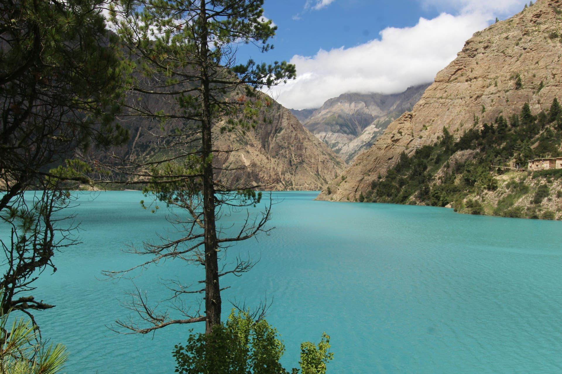
The lake sits at 3,611 metres, is 145 metres deep — the deepest in Nepal — and is an improbable turquoise. The colour comes from an absence: almost no aquatic life, almost no suspended sediment.
Ringmo, the village at its foot, is Bon, and Tshowa gompa on the bluff above the water is around nine hundred years old.
The two passes
The circuit crosses Baga La at 5,169 m and Numa La at 5,309 m on consecutive days, from cold camps, with a nine-hour day and 1,219 metres of descent on the second. This is the part that makes Lower Dolpo strenuous rather than moderate.
Dho Tarap
At 4,090 metres, one of the highest permanently inhabited villages in the world, with Bon and Buddhist households side by side and two gompas within walking distance. The rest day here is well spent.
The way out follows the Tarap gorge — narrow, steep and repeatedly crossing the river — down to Tarakot and Dunai.
Season
May to early October, which is the opposite of most of Nepal, because Dolpo is in the rain shadow. The limiting factor is the flights: Kathmandu–Nepalgunj and Nepalgunj–Juphal are both small and both cancel. Keep spare days at each end or you will miss your onward flight.
Day by day
The 13 days itinerary
Distances, walking times, altitudes and accommodation for every stage — stored as structured data, not written into the prose.
- Day 1
Kathmandu to Nepalgunj
Kathmandu (1,400 m) → Nepalgunj (150 m)
- Walking
- 1 hour by air
- Altitude
- 1,400 m → 150 m
- Sleep
- Hotel, Nepalgunj
- Meals
- Dinner
- Day 2
Nepalgunj to Juphal, walk to Dunai
Nepalgunj (150 m) → Juphal (2,475 m) → Dunai (2,140 m)
- Distance
- 8 km
- Walking
- 35 min flight, 3 hours walking
- Altitude
- 2,475 m → 2,140 m
- Elevation
- −335 m
- Sleep
- Camp, Dunai
- Meals
- Breakfast, lunch, dinner
- Day 3
Dunai to Ankhe
Dunai (2,140 m) → Ankhe (2,660 m)
- Distance
- 16 km
- Walking
- 6 hours
- Altitude
- 2,140 m → 2,660 m
- Elevation
- +520 m
- Sleep
- Camp, Ankhe
- Meals
- Breakfast, lunch, dinner
- Day 4
Ankhe to Sulighat
Ankhe (2,660 m) → Sulighat (3,100 m)
- Distance
- 14 km
- Walking
- 6 hours
- Altitude
- 2,660 m → 3,100 m
- Elevation
- +600 m / −160 m
- Sleep
- Camp, Sulighat
- Meals
- Breakfast, lunch, dinner
- Day 5
Sulighat to Phoksundo Lake
Sulighat (3,100 m) → Ringmo → Phoksundo (3,611 m)
- Distance
- 12 km
- Walking
- 6 hours
- Altitude
- 3,100 m → 3,611 m
- Elevation
- +511 m
- Sleep
- Camp, Phoksundo
- Meals
- Breakfast, lunch, dinner
- Phoksundo waterfall
- Ringmo village
- The lake at first light
- Day 6
Rest day at Phoksundo
Phoksundo (3,611 m)
- Walking
- 4 hours
- Altitude
- 3,611 m → 3,611 m
- Sleep
- Camp, Phoksundo
- Meals
- Breakfast, lunch, dinner
Tshowa, on the bluff above the water, is a Bon monastery around nine hundred years old — one of the oldest religious buildings in Dolpo.
- Tshowa Bon gompa above the lake
- Day 7
Phoksundo to Baga La Base Camp
Phoksundo (3,611 m) → Baga La Base Camp (4,200 m)
- Distance
- 13 km
- Walking
- 6 hours
- Altitude
- 3,611 m → 4,200 m
- Elevation
- +589 m
- Sleep
- Camp, Baga La Base Camp
- Meals
- Breakfast, lunch, dinner
- Day 8
Over Baga La to Numa La Base Camp
Baga La Base Camp (4,200 m) → Baga La (5,169 m) → Numa La Base Camp (4,440 m)
- Distance
- 14 km
- Walking
- 8 hours
- Altitude
- 4,200 m → 4,440 m
- Elevation
- +969 m / −729 m
- Sleep
- Camp, Numa La Base Camp
- Meals
- Breakfast, lunch, dinner
- Baga La at 5
- 169 m
- Kanjirowa Himal
- Day 9
Over Numa La to Dho Tarap
Numa La Base Camp (4,440 m) → Numa La (5,309 m) → Dho Tarap (4,090 m)
- Distance
- 16 km
- Walking
- 9 hours
- Altitude
- 4,440 m → 4,090 m
- Elevation
- +869 m / −1219 m
- Sleep
- Camp, Dho Tarap
- Meals
- Breakfast, lunch, dinner
The longest and hardest day. Nine hours, a 5,309-metre pass, and 1,219 metres of descent into the Tarap valley at the end of it.
- Numa La at 5
- 309 m — the trek's high point
- Dhaulagiri to the east
- Day 10
Rest day at Dho Tarap
Dho Tarap (4,090 m)
- Walking
- 4 hours
- Altitude
- 4,090 m → 4,090 m
- Sleep
- Camp, Dho Tarap
- Meals
- Breakfast, lunch, dinner
- Ribo Bhumpa gompa
- Crag Gompa
- Bon and Buddhist households in one village
- Day 11
Dho Tarap to Khanigaon
Dho Tarap (4,090 m) → Khanigaon (3,150 m)
- Distance
- 18 km
- Walking
- 7 hours
- Altitude
- 4,090 m → 3,150 m
- Elevation
- −940 m
- Sleep
- Camp, Khanigaon
- Meals
- Breakfast, lunch, dinner
Down the Tarap gorge — narrow, steep-sided and spectacular, with the trail crossing and recrossing the river.
- Day 12
Khanigaon to Dunai
Khanigaon (3,150 m) → Tarakot → Dunai (2,140 m)
- Distance
- 20 km
- Walking
- 7 hours
- Altitude
- 3,150 m → 2,140 m
- Elevation
- −1010 m
- Sleep
- Camp, Dunai
- Meals
- Breakfast, lunch, dinner
- Tarakot and its old fort
- Day 13
Dunai to Juphal, fly out
Dunai (2,140 m) → Juphal (2,475 m) → Nepalgunj → Kathmandu
- Distance
- 8 km
- Walking
- 3 hours walking, then flights
- Altitude
- 2,140 m → 1,400 m
- Meals
- Breakfast
Route map
Where the trail goes
Route line, start and end points, and every overnight stop. Locations are shared entities — the same record powers the destination and itinerary pages.
Frequently asked questions
How does Lower Dolpo differ from Upper Dolpo?
Is it really a monsoon trek?
Is Phoksundo really that colour?
Do you need camping?
How hard are the two passes?
About the author
Tom Eriksen
Gear editor & photographer
Tom tests trekking equipment the only way that produces honest answers: by carrying it for weeks at a time above 4,000 metres. He shoots most of the photography on this site and writes the gear reviews, comparison tables and packing lists.
Writes about: Trekking gear · Photography · Packing and weight